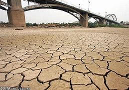
Iranwire – The thousands-strong protests over the water crisis in Khuzestan have refocused attention on an unfolding ecological disaster going back years. Since the turn of the century, Iran has been experiencing “anthropogenic drought”: severe water stress, caused specifically by destructive and unsustainable land and water management, by human beings.

This summer, farmers in Khuzestan have been left unable to irrigate their crops. Buffalo and livestock, birds and wildlife, are dying or else fleeing en masse. Ordinary Iranians, too, are thirsty, and have watched the millenia-old sources of water that have always sustained them dry up before their eyes.
No small wonder: a recent study found that 77 percent of Iran’s land is under extreme “groundwater overdraft”, with more than three times the water being drawn from the country’s 30 river basins and 609 sub-basins than will naturally be replenished.
Today, Khuzestan’s vanishing rivers and wetlands stand as testament to what reckless long-term human activity looks like. Ships used to run almost the length of the Karun River, which supplies some 16 different cities. The basin of the Karkheh River, Iran’s third-longest waterway, is home to nine percent of Iran’s total irrigated lands and feeds 11 percent of itswheat production. But groundwater levels in the Karun and Karkheh basins alone depleted, respectively, by 91,000 and 108,000 hectares between 2002 and 2015 alone.
In the 1970s the Hor al-Azim wetland, a vast and unique marshland with a UNESCO World Heritage status, home to more than 60 species of migratory birds and a huge array of aquatic life and plant species, had an area of more than 300,000 hectares across Iran and Iraq. By 2018, it had shrunk to 130,000 hectares. Some of the key aggravating factors were the construction of the Karkheh Dam from 1992 to 2001, and the wanton razing of the wetlands for oil drilling particularly during tthe Ahmadinejad era.
What does this shrinkage in Khuzestan’s waterways look like from the skies? Below are a series of satellite images of some of the province’s larger bodies of water, from the 1980s to spring 2021.
Drag the sliders to the left and right to see the visual differences over time, or click the Flourish button to view them in a bigger format. As far as possible, we have tried to match each set of images season-for-season.
Hor al-Azim wetlands, December 1984-December 2020

The Karkheh River south of Hamidiyeh, December 2001-December 2020
The Karkheh River east of Susangerd, July 2016-December 2020
The Dezful River, south Dezful, May 2003-March 2021
Shadegan wetlands, December 1985-December 2020
Northeast Hor al-Azim wetlands, December 1988-December 2020
All wetlands, December 1984-December 2020
Lakes at Izeh, December 2001-December 2020
The Jarrahi River, Behbahan, July 2012-October 2020